Loading...

Categoria de Coleção: Engraving

The Soares dos Reis National Museum’s engraving collection covers a period between the 17th and 20th centuries, and includes a diversity of Portuguese and foreign artists.

Ancient engraving in Portugal includes artists in the transition from the 18th to the 19th century. The lithographic technique in the first half of the 19th century is essentially found in portraiture.

Representations of local iconography present late 18th century Porto. Valuable records for the history of town planning feature its main buildings, with the city surrounded by the old defensive wall. The panoramic aspects multiplied in the first decades of the 19th century highlight river views, the riverside routine and the river port. In the thematic line of Historical Iconography, the collection also includes interpretations of political and military events in the city during the first quarter of the 19th century.

Map of Porto

Planta da Cidade do Porto

Frederico Perry Vidal

Lisbon, 1844

Lithography, black ink

Inventory sheet

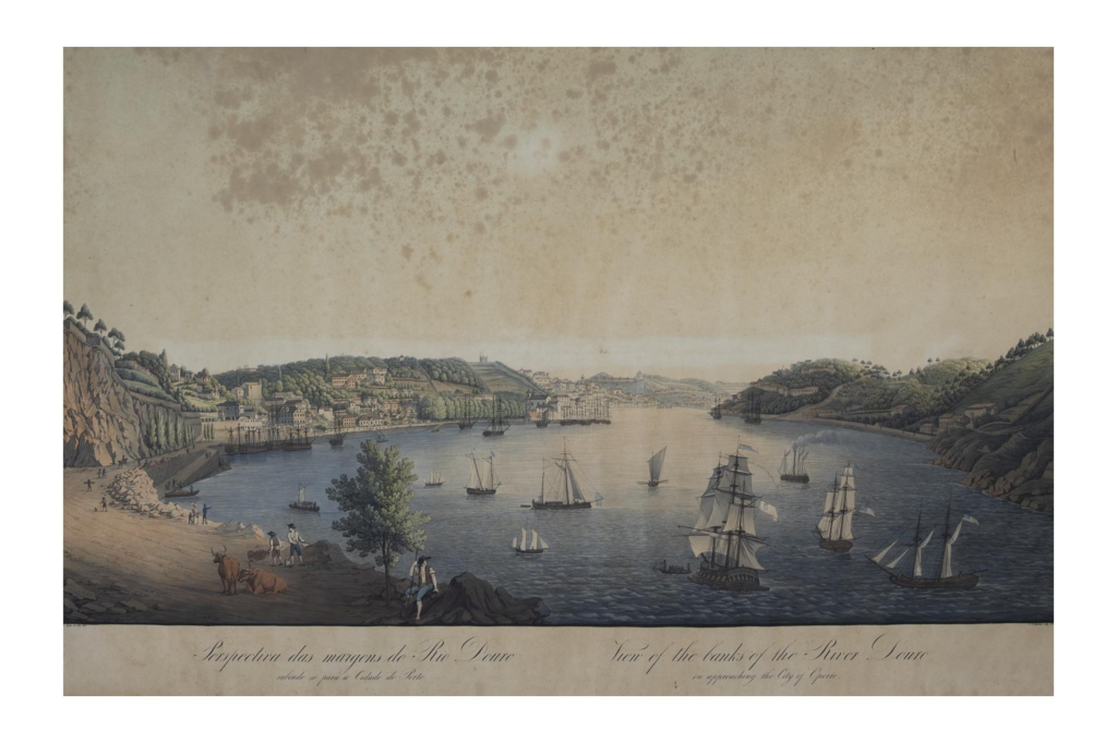
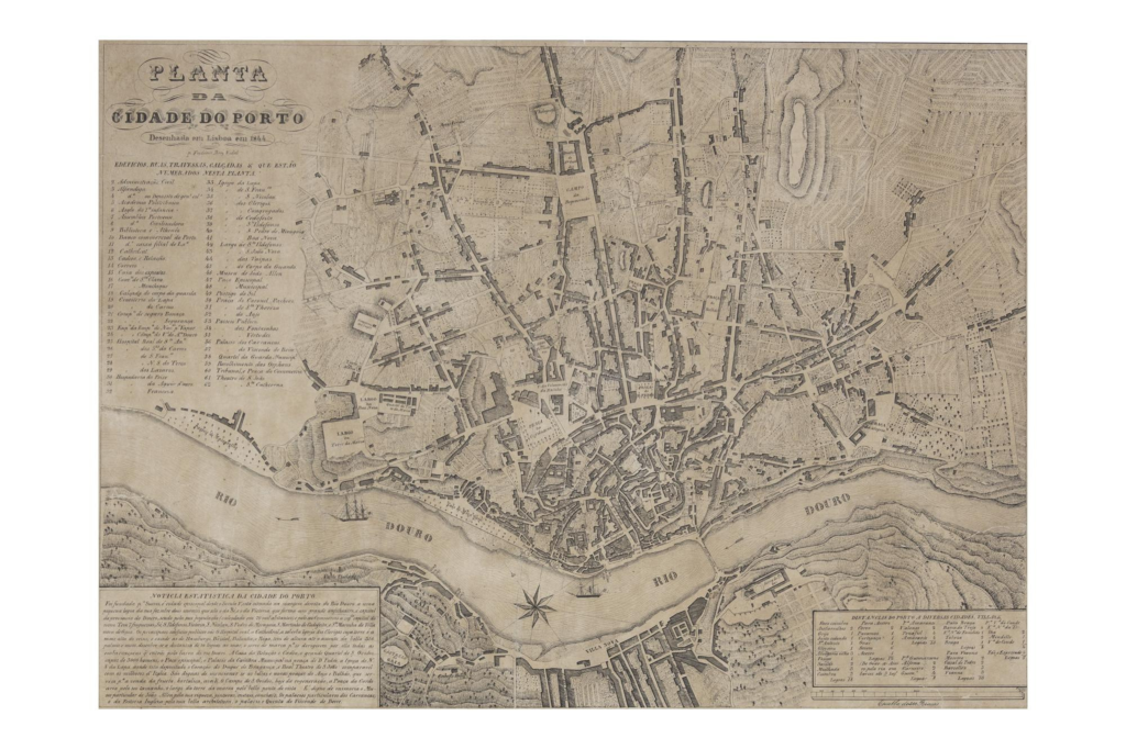
This map shows the Suspension Bridge, inaugurated a year before in 1843, for the first time. It is the only printed map from the first half of the 19th century that shows it.
Perry Vidal’s map points out two new aspects of the city’s progress: the first is the Suspension Bridge, correctly located in the place where it was built; the second, and of great interest for the city’s commerce, is the steamship.
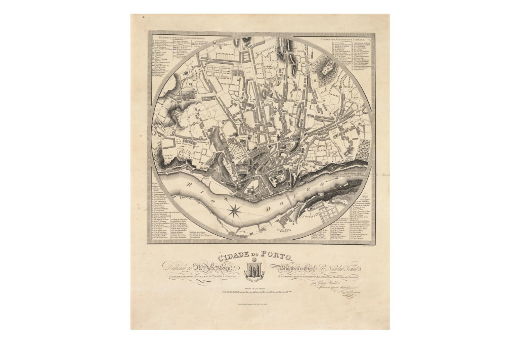
Some important urban changes are indicated: the recently built Praça do Bolhão is shown, as is Rua da Restauração, now open along its entire length and connected to the Massarelos promenade.
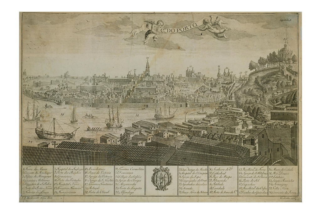
The map also has a caption with the buildings, and the various thoroughfares all numbered.

Porto from Vila Nova

Oporto from Villa Nova

Robert Batty

London, 1830

Steel engraving

Inventory sheet

This engraving is part of the album, Batty’s Views of the Principal Cities in Europe. The artist was Lieutenant-Colonel Robert Batty of the British army, and the album includes six panoramic views of Porto done by Batty during his stay in Porto.
In this engraving, the artist depicts the Douro and, in the distance, the old Ponte das Barcas. Numerous boats are moored on the river in the fluvial port. In the foreground, the Vila Nova bank is populated by people and small boats. The perspective reveals the oldest monumental complex of the city, punctuated by the Episcopal Palace. The Torre dos Clérigos can be seen on the far left. The defensive wall runs along the city by the riverside and up the Guindais hillside.

View from the Royal Palace in Porto

Unkown Author

Lithograph

Inventory sheet

View of Carrancas Palace as temporary residence of the Portuguese royal family after its acquisition in 1862. The lithograph was published in Elogio Histórico do Senhor Rei D. Pedro V by the Marquis of Resende, published in Lisbon in 1867.
The representation of the main façade has some ornamental features added, such as the Cross of Christ, placed at the top of the pediment, and two eagles, at each end, alluding to the royal symbols. It is the only representation of the building as the Royal Palace of Porto.

View of Porto

View of the City Of Oporto

R. Havell (engraving)/ Carlos Van Zeller (drawing)

London, 1833

Coloured Aquatint

Inventory sheet

This rare view of Porto was drawn by Carlos Van Zeller, captain of the British Brigade in the service of Queen Maria II during the Siege of Porto in 1832-33. Produced during the military conflict, the engraving covers the city from a strategic military point, the Serra do Pilar Monastery, partially represented with the damage caused by the fighting. In the foreground, there are some figures in popular dress, such as the varinas, or fishwives, with their large baskets, a water-carrier, and a peasant in a straw cloak. There are also military figures, from the liberal army and the absolutist troops, the latter being the chained prisoners.

The river, crossed by Ponte das Barcas, is traversed by the different boats, such as the rabelos and the ocean-going vessels anchored in its port. The city is seen in the distance, with the wall shown in detail next to the Guindais escarpment. The engraving is accompanied by a captioned and numbered leaflet distinguishing 85 places, city buildings and military batteries.

City of Porto

Cidade do Porto

Manuel da Silva Godinho (engraving); Teodoro de Sousa Maldonado (drawing)

Porto

1789

Copper engraving, black ink

Inventory sheet

Inserted in chapter I of Descripção Topographica e Histórica da Cidade do Porto, published in 1789, this is the first Portuguese engraving depicting the city in the late 18th century.
The view of the city stretches from the Torre da Marca, in the west, to S. Lázaro, at the eastern end of the city. The defensive wall of the old town was maintained throughout its extension and its gates are indicated, where the main ones had, duly indicated, fortified watchtowers. Among the main buildings indicated, the large number of convents existing within the walls is noted. The representation is accompanied by a caption showing the 56 main buildings in the city.
This copy belongs to the first edition and is one of the most reproduced engravings of Porto to date.

View of the Serra do Pilar and the Suspension Bridge

Vista da Serra do Pilar e Ponte Pênsil

Joaquim Manuel das Neves

Black ink and chisel engraving

Inventory sheet

Spontaneous recording of the customs activity of the old fluvial port located on the Ribeira.
On the quay, the barrels are hoisted from a vessel by means of cranes and the ox cart awaits its loading. On the river are the Valbom boats that used to transport the barrels between the two banks of the river. Near the Vila Nova bank, a steamboat is represented and, in the distance, we can see the old suspension bridge (1843-1877). This bridge was a daring work for its time, built by the French engineer, Stanislás Bigot. Its slightly elevated construction safeguarded it from the river floods.

Porto

Samuel John Neele

London, 1813

Paper and black ink

Inventory sheet

Known as the round map, this is the oldest map of Porto’s urban centre. Its survey was carried out during the Peninsular War with the British army still present in the country. Its survey was carried out during the Peninsular War and the English military presence in the country.
Done with great care, it covers the area bounded to the south by the banks of Gaia, to the north by Lapa Church, to the east by Rua Direita until Campo do Poço das Patas and to the west by the Torre da Marca vicinity. Its captions present 28 public buildings and squares; 76 streets and alleys; besides 29 convents, colleges and churches.
This printed copy of the first edition is extremely rare.

The characters’ clothes and activities are also meticulously presented.

Unknown artist

Etching

Inventory sheet

This engraving represents the tragic episode of the ‘Ponte das Barcas’ disaster on 29th March 1809, which occurred during the Peninsular War. Popular in character, probably by a local artist, it is one of the most faithful depictions of the catastrophe. It documents, next to the Ribeira quay, the entrance of the French cavalry and the hasty flight of the city’s inhabitants, causing the bridge formed by 20 barges to collapse. On the left of the engraving, we see the bridge breaking, causing many of those fleeing the city to drown.

View of Porto from Torre da Marca to Fontainhas

Manuel Marques de Aguillar

1791

Etching and chisel

Inventory sheet

This is one of the most important late 18th century depictions of Porto. It records the city encircled by the old wall built in the 14th century for the town’s defence, whose perimeter went from the Forte da Porta Nova to the Porta das Virtudes, descending from the Porta do Sol and going on to the river at Guindais, where a small stretch still survives today.
The engraving depicts the boats and riverside activities at Vila Nova: a Portuguese frigate under construction and others under repair. Valbom boats or passing barges are moored at the quay and, on the beach, a rabelo boat unloads barrels. The characters’ clothes and activities are also meticulously presented.

View of the banks of the River Douro rising to Porto

Guilherme (?) Kopke (drawing) / Christian Gottlob Hammer (engraving)

Dresden, 1827

Coloured mezzotint

Inventory sheet

The panoramic view is of an area close to the Arrábida mountain range, with the city in the background. The river is, as would have been usual, crowded with boats, and the Portuguese ship, the Lusitânia, can be seen in the foreground, among others of different nationalities. A steam boat moves up river, which was a novelty at the time.
Believed to be a faithful representation of this part of the city, the engraving is by a member of the Kopke family, originally from the Hanseatic Cities (located in present-day Germany), who had been settled in Porto since 1638. The family lived in Massarelos and Vilar, the area covered by the panoramic view. The artist, though certainly an amateur, was a skilled draughtsman among other foreigners who lived and depicted Porto at that time.